
It is the most intense tropical cyclone in terms of energy released by a tropical cyclone during its lifetime and the third-deadliest tropical cyclone ever recorded in the Southern Hemisphere: scientists at work with machine learning and climate intelligence to allowing an optimal response and preparedness to events like Freddy.
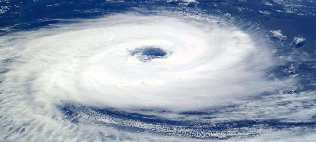
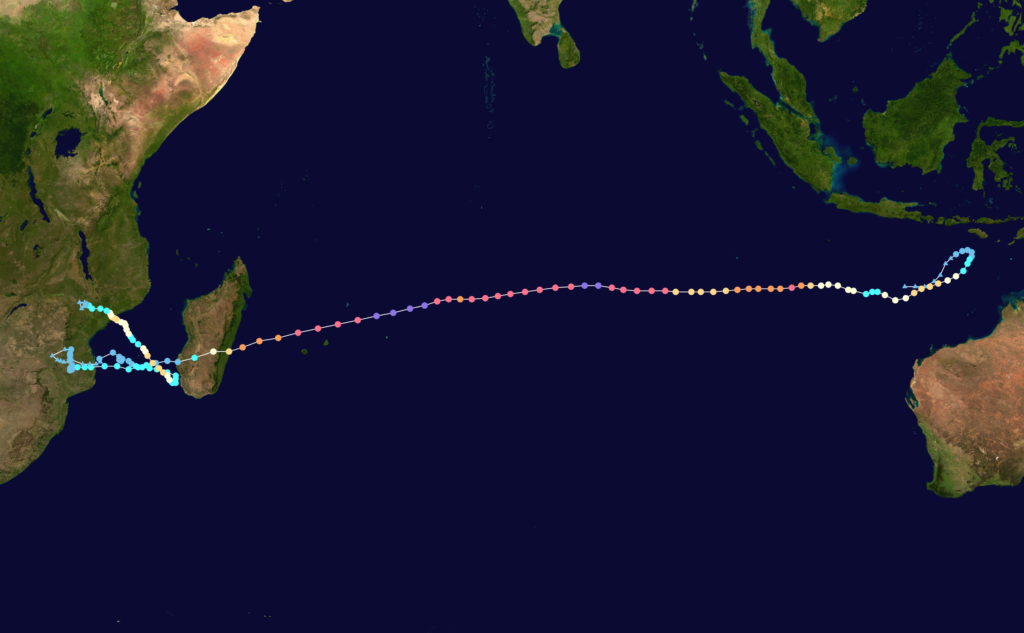
Cyclone Freddy has recently made the headlines worldwide because of its destructive impacts on land and its record-breaking intensity. Indeed, Freddy had quite a peculiar behaviour. It developed near the western coast of Australia at the beginning of February 2023, and it crossed the Southern Indian Ocean westward, reaching the eastern coast of Africa over a few weeks. It made a first landfall on Madagascar, crossed the Channel and made landfall over the coast of Mozambique.
Typically, cyclones are fed by heat and energy from the ocean, so they lose intensity when they touch land and tend to dissipate. Unusually, instead of dissipating after landfall, Freddy travelled back to the ocean, where it gained more energy and inverted its direction, hitting land again over the coast of Mozambique and then over Malawi. This uncommon behavior made it the longest tropical Cyclone ever recorded, with a duration of 38 days, beating the previous record of 30 days by more than a week and travelling a total distance of more than 8,000 kilometres.
Freddy is now also recognized as the most intense tropical cyclone ever recorded in terms of accumulated cyclone energy (ACE), a metric which expresses the energy released by a tropical cyclone during its lifetime.
This metric is particularly convenient because it gives an estimate of both the cyclone’s intensity, which is typically its maximum velocity, and its duration, giving a measure of the dissipated energy, which is more representative of the cyclone’s overall activity. According to NASA, Freddy is the highest-ACE-producing tropical cyclone ever recorded worldwide.
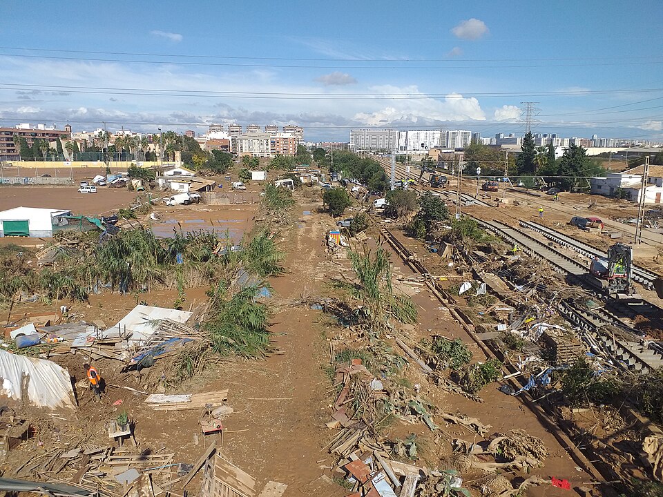
Unfortunately, Cyclone Freddy stood out also for its violence and destructive force, being the third-deadliest tropical cyclone ever recorded in the Southern Hemisphere, after Cyclone Idai in 2019 and Flores cyclone in 1973. It produced extraordinarily heavy rains, strong winds, and excessive flooding, destroying houses, crops, and infrastructures, primarily in Mozambique and Malawi.
The death toll in South-East Africa is estimated to be hundreds, with Malawi being the most affected country. The cyclone further compromised communities already struggling with the spread of cholera and often lacking an adequate healthcare system to respond to emergencies.
As reported by Reuters, Malawi President Lazarus Chakwera said that “the death toll from Cyclone Freddy has risen sharply to more than 1,000 people”. Hundreds of people are still missing in the region, and more than half a million are displaced.
The role of climate change
But do these extremes follow an overall tendency in worsening extreme climate events? And is this caused by climate change?
Attribution science, or extreme event attribution, is a relatively recent field in climate science that tries to quantitatively determine if an extreme weather event was caused or worsened by climate change or was simply due to natural variations.

The Intergovernmental Panel on Climate Change (IPCC) had already warned in its reports about an expected rise in intense precipitations, floods, mean wind speed and tropical cyclones, with stronger associated precipitations, in the areas of South-East Africa and Madagascar.
However, it is not always easy to clearly determine if climate change plays a crucial role in the occurrence of an extreme event, and rigorous analyses are not yet available in the case of Cyclone Freddy.
There are mainly two ways to do an attribution analysis for an event such as a tropical cyclone.
The first is of a statistical kind: analyzing the number, frequency, intensity, and impacts of extreme events like Freddy that happen in the present, and making a comparison with the same parameters from pre-industrial times, can give an estimate of the possible influence of climate change on these phenomena.
Another way is to analyse a particular storm through model simulations under different conditions typical of the past, the present, and the future. This will point out under which climate scenario a storm would be more likely.
Climate Intelligence
“Many studies have been carried out at CMCC to try and understand the effects of climate change on tropical cyclones,” says Enrico Scoccimarro of the Climate Simulations and Prediction (CSP) division at the Euro-Mediterranean Center on Climate Change (CMCC). “On one hand, it is true that with a warmer climate we have a more stable atmosphere, and thus we expect less tropical cyclones. On the other hand, however, it is also true that a higher availability of energy in the ocean leads to more intense storms. Moreover, if a storm happens to go back to the ocean, it has a higher probability to re-strengthen and hit land again, and this is just what happened with Freddy recently.”
A crucial factor in the creation of the perfect storm is the stratification of the ocean. Tropical cyclones are characterized by a mechanism of negative feedback that tends to slow-down and sometimes dissipate the storms. Cyclones absorb heat from water while crossing the ocean, and gain energy from it, making it cooler. In addition to the induced upwelling, in which cooler layers from the bottom of the ocean travel upwards, a process of turbulent mixing of water layers also takes place. With less heat available on the surface, slower cyclones tend to lose their strength and slowly fade, while faster and more violent storms tend to proceed almost undisturbed.
“The point is that this negative feedback is more or less efficient depending on the storm speed and on the level of ocean stratification,” says Scoccimarro. “The stratification is not the same in past or future climate scenarios, and it also varies in the different areas of the world. On average, in a warmer climate, more intense storms are more likely to happen. In a changed climate, we will likely have fewer storms, but they will likely be much more intense.”
CLINT (CLimate INTelligence) project has the goal to improve detection methods of extreme events and their causation and attribution through Machine Learning techniques. Extreme events include not only tropical cyclones but also heat waves or floods, and the project has a focus on South-East Africa for analysing extreme precipitation associated with cyclones. “We are trying to develop improved tools to better quantify the amount of precipitation in the area, in this case, associated with cyclone Freddy,” says Scoccimarro. “This could also be useful to characterize floods and drought events on the dominion of the Zambesi River, which is very close to the impacted areas.”
Predicting the birth of a cyclone like Freddy is not straightforward, but there are parameters and models that can be used to determine if the physical conditions of an area over a certain period of time are favourable. Genesis potential indexes (or GPI) are generally empirical formulations that give an estimate of the occurrence of a tropical cyclone in a cell of 5 degrees longitude by 5 degrees latitude. “Within the CLINT project, we are using Machine Learning to improve this empirical index,” said Scoccimarro. “That is, we are working to improve the correlation of this index and the actual occurrence of a cyclone in a certain area, which is crucial for allowing an optimal response and preparedness to disasters.”
____________________________________________
Originally post on https://www.climateforesight.eu/